
Orange heavy rain warnings still in place in south as bad weather moves north
More rain is forecast to fall on the West Coast overnight and orange heavy rain warnings remain in place for Buller, Westland and Southland, as of Thursday night.
MetService said heavy rain and strong north to northeast winds were forecast for many places.
Large waves were expected to affect the West Coast of the South Island and heavy rain was forecast for the far south of the South Island, MetService said.
It continued to be a significant weather event for Westland, MetService said in its latest update.
The bad weather is also now hitting the North Island, with orange level heavy rain warnings in place for Bay of Plenty, Taranaki and Coromandel Peninsula.
MetService meteorologist Heath Gullery told the Nights programme Westland’s orange rain warning was in place until 6am on Friday.
“There’s going to be improvements in weather across the South Island, so those areas like Southland and Fiordland, up the West Coast through Westland Buller, and the top of the south Island which has also seen some significant rain around Tasman and northern Marlborough – all of those areas will see an improvement throughout tomorrow, rain becoming patchy and light.”
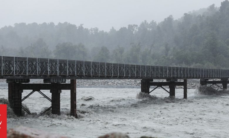
More than 800mm of rain has fallen in parts of Westland over the last two and a half days, and there was concern about how high two major rivers would get.
Hokitika and Waiho Rivers peaked over their warning level on Thursday night, but have since been dropping, and were being closely monitored by emergency officials.
These are the South Island areas under an orange level heavy rain alert, note that the rain amounts are in addition to what has already fallen in the area.
- Westland District south of Hokitika up to 80mm of rain is expected from 8pm Thursday to 5am Friday
- Buller up to 45mm of rain from 8pm Thursday to 2am Friday
- Southland up to 40mm of rain from 8pm Thursday to 3am Friday
- Nelson up to 80mm of rain from 8pm Thursday to 2am Friday
- Marlborough, Nelson in the Bryant Range, also inland Marlborough west of Blenheim and north of the Awatere River up to 120mm from 8pm Thursday to 9am Friday
- Canterbury High Country up to 80mm within 20km east of the main divide from 8pm Thursday to 5am Friday
- Southern Lakes up to 50mm of rain east of the main divide from 8pm Thursday to 7am Friday
Gullery said the front was forecast to move across central and upper North Island overnight and then eastwards through those areas on Friday.
“We do have a series of heavy rain watches and warnings, extending down from Northland down to Taupo and across the Bay of Plenty and with that rain there is the possibility of localised downpours.”
In the North Island, there are three areas under an orange level alert, although several other areas are under severe thunderstorm watches and heavy rain watches.
- Coromandel Peninsula up to 120mm from 3am Friday to 3pm Friday
- Bay of Plenty, Rotorua up to 160mm of rain from 4am Friday to 11pm Friday
- Taranaki at Mount Taranaki up to 180mm from 8pm Thursday to 11am Friday
RNZ is New Zealand’s statutory civil defence lifeline radio broadcaster, providing vital information and updates as they come to hand.
Check out the frequencies here.
The National Emergency Management Agency (NEMA) advises that in times of crisis or civil defence emergency a battery powered radio or a car radio remain essential lifelines if power is out and other forms of communication are unavailable.
More than half a metre of rain with more to come
Some parts of the West Coast had already recorded 800mm of rain by Thursday evening, with more set to come before the orange level heavy rain warning expires on Friday.
Motorists were being urged to stay off the roads in the Westland District on Thursday evening and to only travel if necessary.
West Coast Emergency Management said the roading network across the district had been affected by the bad weather and trees were down, a number of roads were closed and slips and surface water were making driving hazardous.
UPDATE 7PM, THU 11 APR
SH6 Ross and Makarora is now CLOSED. Avoid travel through the area.
CLOSED
• SH6 Ross to Franz Josef – Next update 10am Fri 12 Apr
• SH6 Franz Josef to Fox Glacier – Next update 12pm Mon 15 Apr
• SH6 Fox Glacier to Makarora – Next update 10am Fri 12 Apr https://t.co/Nnu3wZvXNW pic.twitter.com/9oqE17C8Xc— Waka Kotahi NZTA Canterbury & West Coast (@WakaKotahiCWC) April 11, 2024
Marlborough Civil Defence is asking 70 households in the township of Spring Creek near Blenheim to evacuate their homes by 9am on Friday due to the risk that a river stopbank might fail.
Heavy rain moving through from the upper Wairau catchment is expected to raise the Wairau River level significantly on Friday.
Twenty Civil Defence and iwi volunteers were door knocking and leafletting the 70 homes on Thursday evening. Residents were told they could evacuate on Thursday night if they wished.
A power outage at Hannahs Clearing was worse than originally thought, and the area remains disconnected due to the loss of several power poles.
Westland Emergency Management said areas south of Hannahs Clearing, including Arawhata, Jackson Bay and Neils Beach, were likely to be without power for several days. An update on the timeframe for it being restored was expected at midday on Friday.
⚠️It’s going to be a busy overnight and Friday morning across the upper North Island as a front will bring heavy rain and strong winds.
️The heaviest rain is likely to affect the Coromandel and Bay of Plenty, where up to 100 mm in only a few hours will bring a flooding concern. pic.twitter.com/zY1eULT2Mi
— NIWA Weather (@NiwaWeather) April 11, 2024
On Thursday evening, the bad weather cancelled or delayed about 60 domestic arrivals and departures at Auckland Airport as strong winds buffeted the region.
Fire and Emergency said it had had about 18 callouts in the Auckland region, relating to trees coming down and powerlines lifting and there were isolated power outages.
There is a severe thunderstorm watch in place for Auckland until 2pm on Friday.
According to the news on Radio New Zealand